About FAA Charts
Viewer that allows download of FAA Sectional Charts, WAC charts, Terminal Aera Charts, IFR Low Enroute Charts and street maps. OSM Streetmaps are used to provide street maps. 1) Provides overlay of users current position...
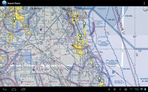
Viewer that allows download of FAA Sectional Charts, WAC charts, Terminal Aera Charts, IFR Low Enroute Charts and street maps. OSM Streetmaps are used to provide street maps.
1) Provides overlay of users current position on map.
2) Provide METARS/TAF of users present position
3) Provide METARS/TAF of map center
4) App uses network to donwload map initially. with subsequent map location access the map files are stored and can be utilized inflight
5) Searchable database of Airport info. Frequencies, Fuel prices and runway info.
The Federal Aviation Administration (FAA) world raster aeronautical charts are made to meet the needs of pilots users who require georeferenced images of FAA visual flight rules world charts.
Previous Versions
Here you can find the changelog of FAA Charts since it was posted on our website on 2013-08-22 13:03:30.
The latest version is 1.12 and it was updated on 2024-04-19 22:07:41. See below the changes in each version.
FAA Charts version 1.12
Updated At: 2014-08-04
FAA Charts version 1.7
Updated At: 2013-06-28
Changes: Several fixes and updates
Disclaimer
Official Google Play Link
We do not host FAA Charts on our servers. We did not scan it for viruses, adware, spyware or other type of malware. This app is hosted by Google and passed their terms and conditions to be listed there. We recommend caution when installing it.
The Google Play link for FAA Charts is provided to you by apps112.com without any warranties, representations or guarantees of any kind, so access it at your own risk.
If you have questions regarding this particular app contact the publisher directly. For questions about the functionalities of apps112.com contact us.